Groundwater and lake management by means of global datasets
How do groundwater level and lake level trends correlate with precipitation and climate trends? In other words, what is the influence of climate change on the volume of water that can be extracted from groundwater? An what is the influence of climate change for small shallow lakes, which are the vast majority of lakes around the globe?
To solve such a paramount importance problem, a multi-disciplinary approach is needed. General Circulation Models (GCM), which consider all relevant physical factors, should be used for understanding aquifers and lakes response to climate change as a basis for water use policies. That said, this question arises: is the refining of a reliable GCM within the reach of any water supply company? In other words, which water supply company is so important that it can include all the needed capabilities in its staff? On the economical side of the problem, a further tie rises: does the dynamics of fundings – in many cases resulting from a hand-to-mouth policy – allow preparing reliable management tools on time? In the real world, water resources are not managed by means of shared criteria, each single water company has to solve its problems separately. In such a case, even if CGMs provided by research centers were used, to obtain realistic results statistical downscaling techniques should be employed to bridge the local- and synoptic-scale process by considering a number of factors including evaporation and precipitation intensity and timing, topography, vegetation, and soil properties. In a word, a quite complex procedure which also needs an interdisciplinary approach. Moreover things are made more complicated by the fact that in many cases the water table behavior and its links with the users – i.e., the effects of groundwater extraction and pumping criteria – is not known at a regional scale. This is true also for the lake levels and its extraction for civil and economical purposes. In most cases only some local water table measurements and extracted volumes are available, often close to the most important well-fields. This is the case also for lakes, of which records of withdrawals from the lake and lake discharges are not available or are absent. Situation is more critical for minor groundwater resources (i.e., those with a small withdrawn discharge) for which also the delineation of the protection areas is often a hard task.
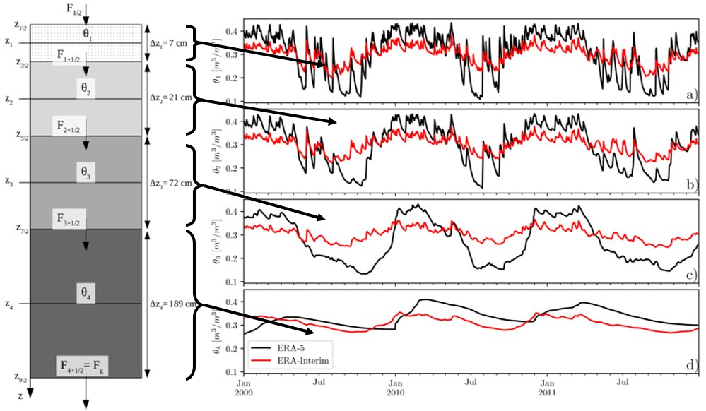
In the above scenario, where climate change plays a more and more critical role and, in some sense, exalts management problems, the importance of the global atmospheric datasets has to be pointed out. Particularly, for monitoring climate change, ECMWF (European Centre for Medium-Range Weather Forecasts) – as well as other global research centers – periodically uses its forecast models and data assimilation systems to reanalyse archived observations, creating global data sets describing the recent history of the atmosphere, land surface, and oceans. It is worthy of noting that such climate observations range from early in-situ surface observations made by meteorological observers to modern high-resolution satellite data sets. In this preliminary phase of the research, on one hand, data from ERA-Interim and ERA5 – reanalyses of meteorological observations made by ECMWF – are used for exploring if a link exists between the trend of soil moisture and local water table data. On the other hand, the land component of the ERA5 reanalisys, at higher resolution, ERA5-Land, has been used to study the evolution of lake water levels through the use of a mass water balance. ERA5-Land has been chosen, since it is the only renanlysis which includes the lakes’ representation at the surface.
Concerning small shallow lakes, the modeling using reanalysis would be a new addition to some already existing methods, which, however, lack generality, considering data that are often local and are generally applied to larger and deeper lakes. With regard to unconfined aquifers, such a link would represent the first stone on which a simplified – but physically based – model could be built to predict the behavior in time of groundwater resources. The aim of this work is ultimately to refine a reliable water balance and the related investments for water supply and distribution systems in line with climate change.

Publications
Bongioannini Cerlini, P., Saraceni, M., Silvestri, L., Meniconi, S., & Brunone, B. Monitoring the Water Mass Balance Variability of Small Shallow Lakes by an ERA5-Land Reanalysis and Water Level Measurement-Based Model. An Application to the Trasimeno Lake, Italy. Atmosphere (MDPI), 13(6), 949. https://doi.org/10.3390/atmos13060949 (2022)
Bongioannini Cerlini, P., Silvestri, L., Meniconi, S., & Brunone, B. Simulation of the Water Table Elevation in Shallow Unconfined Aquifers by means of the ERA5 Soil Moisture Dataset: The Umbria Region Case Study. Earth Interactions, 25(1), 15-32. https://doi.org/10.1175/EI-D-20-0011.1 (2021)
Bongioannini Cerlini, P., Meniconi, S., & Brunone, B. Performance ofGlobal Atmospheric Datasets towards Groundwater Management. EPiC Series in Engineering, 3, 290-294. https://yahootechpulse.easychair.org/publications/download/dKqz (2018)
Bongioannini Cerlini, P., Meniconi, S., & Brunone, B. Groundwater supply and climate change management by means of global atmospheric datasets. Preliminary results. Procedia Engineering, 186, 420-427. https://doi.org/10.1016/j.proeng.2017.03.245 (2017)